Possible Hurricane Forming in the Atlantic This Week
Potential Tropical Cyclone Five could become Hurricane Ernesto this week, possibly affecting Puerto Rico and Bermuda. Stay updated on the latest forecast.
A new hurricane may be brewing in the Atlantic Ocean, with early predictions suggesting it could develop later this week. Fortunately, initial forecasts indicate that the storm might avoid making landfall on the continental United States.
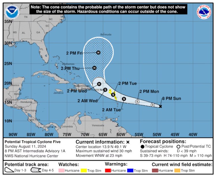
On Sunday, the National Hurricane Center (NHC) began issuing advisories for a system designated as Potential Tropical Cyclone Five, currently located in the central Atlantic. This classification is used when a weather system isn't yet fully developed into a tropical depression or storm but has the potential to bring similar effects to land.
Meteorologists anticipate that Potential Tropical Cyclone Five could intensify into Tropical Storm Ernesto by Tuesday and potentially strengthen further into Hurricane Ernesto by Wednesday.
According to the NHC’s initial forecast, the projected path of this system is expected to keep it away from the U.S. East Coast. However, it could approach Puerto Rico as a strengthening tropical storm by mid-week.
As of Sunday evening, no watches had been issued for Puerto Rico, but that could change later tonight. Meanwhile, tropical storm watches are currently in effect for several parts of the Leeward Islands.
At 7 p.m. CDT on Sunday, Potential Tropical Cyclone Five was positioned approximately 875 miles east-southeast of Antigua, moving swiftly west-northwest at 23 mph. The system was sustaining winds of 30 mph but needs a well-defined center of circulation and wind speeds of at least 39 mph to be classified as a tropical storm and named. If it reaches that threshold, the storm will be named Ernesto, following the 2024 Atlantic storm naming convention.
Tropical storm watches are now active for Guadeloupe, St. Kitts, Nevis, Montserrat, Antigua, Barbuda, Anguilla, Saba, St. Eustatius, St. Martin, and Sint Maarten.
Residents in the Leeward Islands, as well as the British and U.S. Virgin Islands and Puerto Rico, should monitor the storm’s progress closely, as these areas could be placed under a watch by tonight or Monday.
The current forecast from the NHC predicts that the system will pass through the Leeward Islands and then near Puerto Rico, with a possible northward shift in its trajectory before it reaches the Bahamas. While it is likely to remain east of the U.S. East Coast, Bermuda may still be at risk, though it’s too early to determine the exact impact.
The storm could bring 4 to 6 inches of rain to the northern Leeward Islands and 3 to 6 inches to Puerto Rico.
As of now, no other storm systems are threatening the Atlantic Basin.